Welcome to Historic Walnut Park
History. Architecture. Community.
“Unlike surrounding neighborhoods…Walnut Park did not have any exclusionary ethnic clauses written into property deeds.”
About Walnut Park
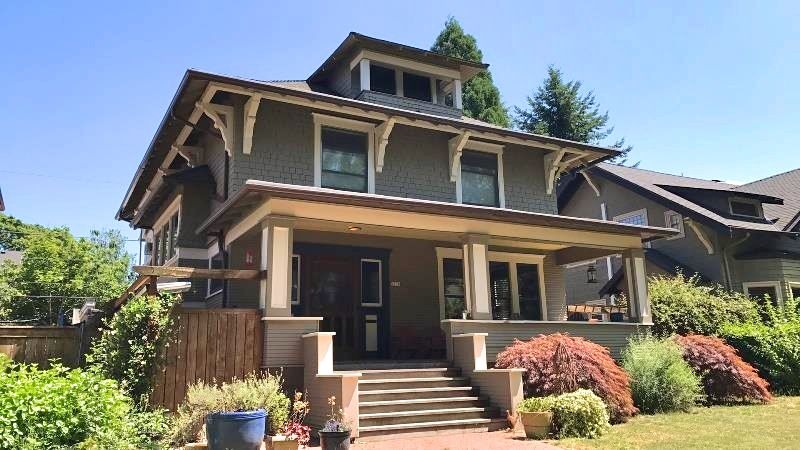
Established in 1904, Walnut Park is a largely residential district within the beautiful King Neighborhood in Northeast Portland, Oregon. 81% of Walnut Park’s 170 buildings were constructed between 1905 and 1929.
This website is managed by Walnut Park neighbors interested in its history. You can learn more about the neighborhood below or find out what we’re doing to preserve our history and how you can help.
Note: We are very grateful to Restore Oregon who, along with Walnut Park residents, conducted research and a neighborhood survey to produce a report titled What’s In Walnut Park. This site draws heavily from this report.
Learn More
Location & Setting
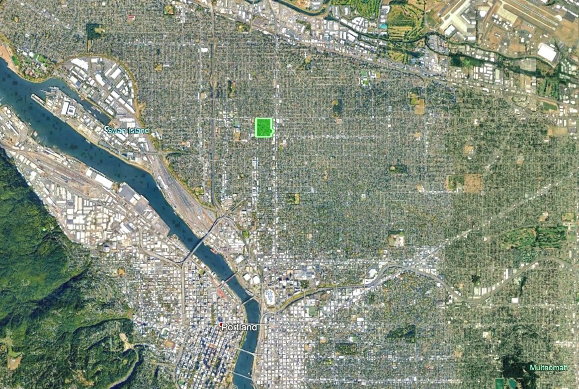
NE Portland Neighborhood
The Walnut Park survey area is in Northeast Portland and is situated on a wide, relatively flat terrace above the Willamette River, which is located approximately one and a half to two miles west. The confluence of the Willamette and Columbia Rivers is approximately eight to ten miles northwest. Prior to settlement, dense coniferous forests dominated the area.
The land that became Walnut Park was surrounded by already developed neighborhoods when it was platted in 1904. The 1889 Piedmont neighborhood, which is now a city conservation district, borders Walnut Park to the north. Central Albina Addition, platted in 1888 by Frank Warren and William M. Killingsworth, borders Walnut Park to the southwest. The area within Walnut Park included in this survey borders the 1889 Maegly Highland subdivision to the southeast, also platted by the pair.
Situated in what used to be the City of Albina, research has shown that Walnut Park was one of the last sections of this urban area to undergo development. (Source: Restore Oregon)
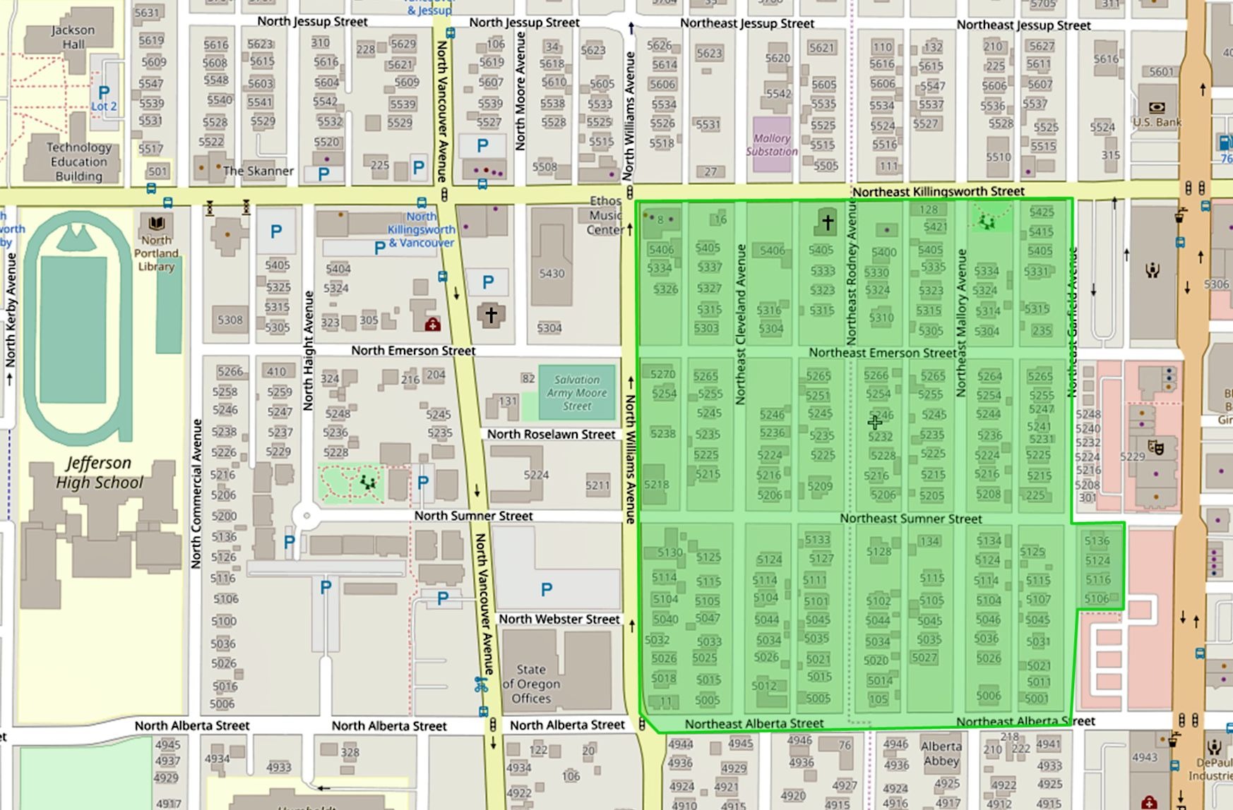
The Survey Area
The survey area is defined by NE Killingsworth Street to the north and NE Alberta Street to the south. These are the original north and south boundaries of the 1904 plat of Walnut Park. The study area is defined by N Williams Avenue to the west.
The Vancouver-Williams couplet, while part of the original plat, has seen development and growth with the construction of contemporary buildings. This development, and the change in building type and use from residential to commercial, provides an obvious western boundary.
Similarly, NE Garfield Avenue, the eastern boundary, has seen re-development and is defined by several vacant lots. A small section of the street at the southeast corner of NE Garfield Avenue and NE Sumner Street remains intact and was included in the survey. (Source: Restore Oregon)
“The history of Walnut Park is indicative of changing trends in Portland’s history.”
Community History
Early Walnut Park (1880s-1940)
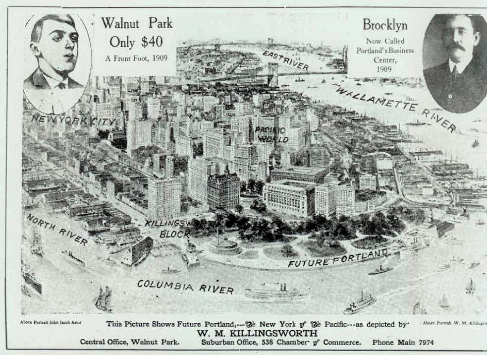
In 1882, Frank M. Warren and William M. Killingsworth, two of the four men that platted Walnut Park, jointly purchased sixty of the eighty acres. The first mention of “Walnut Park” in The Oregonian occurred in 1896, when the “Society” section reported on a leap year party hosted at the Killingsworth house. Over time, they made a series of smaller purchases and eventually owned the full eighty acres that make up Walnut Park today. Walnut Park was platted in 1904, and its later development coincided with the 1905 Lewis and Clark Exposition. Portland expected a population boom as a result of the exposition, and Killingsworth and his fellow investors platted the new neighborhood to take advantage of this anticipated growth.
Killingsworth was a realtor who actively promoted and sold the land for investors. He went to great lengths to advertise Walnut Park as “grand, sublime, unobstructed beauty.” His advertisements in The Oregonian often included descriptions of the natural beauty within Walnut Park. He bragged about how visitors would “become enchanted with the beauties of this lovely park.” (Source: Restore Oregon)
Unlike surrounding neighborhoods, such as Irvington, Alameda, or Laurelhurst, Walnut Park did not have any exclusionary ethnic clauses written into property deeds. Early residents of Walnut Park included first- and second-generation European immigrants. In addition to Irish immigrants, first- and second-generation German, Russian, and Scandinavian immigrants bought and built homes in Walnut Park in the early twentieth century.
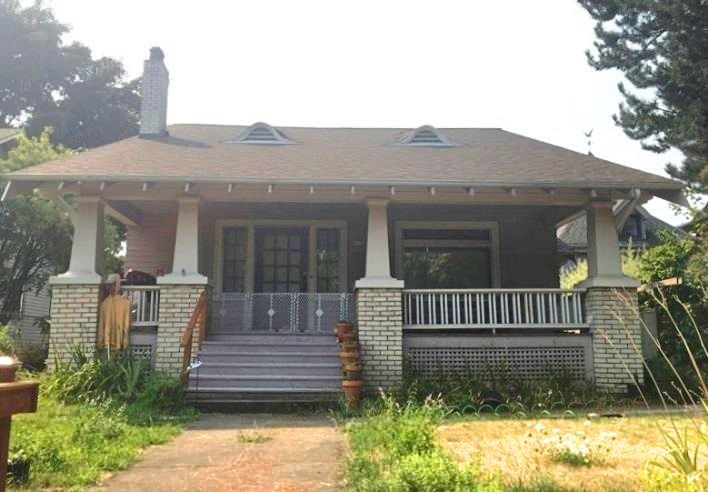
[An] example of early immigration to Portland can be found in the story of Fred and Archie Tunturi, who lived at 5115 NE Garfield Avenue. Fred Tunturi, a Finish immigrant, moved to Walnut Park in 1921. He worked as a barber in Finland and continued his barber business in Portland. He purchased a lot in Walnut Park and built a one-story frame bungalow, completed in 1921. Fred’s son, Archie, grew up in the house, moving there when he was only five years old. After Fred and his wife, Ina, divorced around 1930, Ina and Archie remained in the house in Walnut Park. Archie went on to work at the University of Oregon Health Sciences School and became a renowned medical researcher, best known for his work on the brain and spinal cord. (Source: Restore Oregon)
New Arrivals and Redlining (1940-1970)
As the 1940s approached, the demographics of Walnut Park began to change. While it remained a primarily working- to middle-class neighborhood with European immigrants, African American families also began to move into the area. With the threat of war looming over the country, shipyards, including the Kaiser Shipbuilding Co., along the Willamette River began to move African American men into the Portland area to help with labor shortages. In the period between 1940 and 1950, Portland’s African American population increased ten-fold. This shift in demographics did not come without backlash. Due to exclusionary covenants restricting African American buyers in several of the city’s neighborhoods, these families started to move into North and Northeast Portland, especially around the Albina area [including Walnut Park].
Not only did some Portland communities have neighborhood-specific restrictions on who could and could not buy, but the Portland Realty Board also participated in discriminatory housing practices… prohibiting members… from selling to African Americans and Asian Americans in white neighborhoods. In 1945, as many men were moving to Portland to work for wartime labor, African Americans had only two options for housing: Vanport, the federal housing project, or areas in redlined neighborhoods. All of Albina was shaded in red by the Home Owners Loan Corporation.
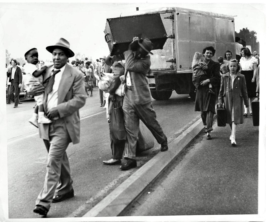
Housing discrimination in the city caused African Americans to struggle to find adequate housing during and after the wartime effort. White flight occurred as more African American families searched for housing in Northeast and white families moved out of the neighborhoods. The 1948 Vanport flood displaced thousands of people, many of whom were African American laborers from the shipyards. The flood led more families to move into the redlined districts of North and Northeast Portland, which ultimately led to more overcrowding of the Albina area and a concentration of Portland’s African American population.
One example of an African American couple moving into North and Northeast Portland can be found in the story of John W. and Ernestine Wiseman. The Wisemans moved to Portland in 1945 from Texas. John served as a sergeant in the Air Force and Ernestine was active in the Council of Negro Women, serving as president in 1966. The Wisemans bought the house at 5225 NE Rodney Avenue in 1958, living there for almost twenty years. A similar story is that of Bill and Theresa Benton. Bill, born in Arkansas, joined the army and received his discharge in Seattle in 1945. In 1947, the couple moved to Portland to a house on NE Cook Street. In 1961, they moved to 5045 NE Mallory. Bill owned and operated Bill’s Neighborhood Grocery Store on N Williams. (Source: Restore Oregon)
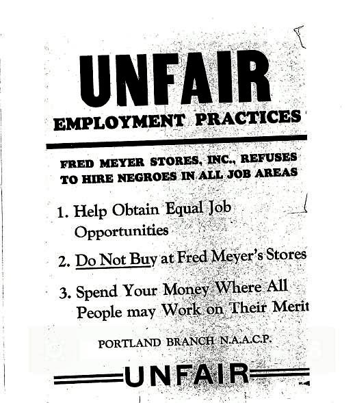
Disinvestment did not stop the African American community from fighting for better treatment and equal rights. In the 1960s, community members boycotted the Walnut Park Fred Meyer, located at the corner of NE Killingsworth Avenue and Union Avenue. Sparked by the discriminatory hiring practices of the store, boycotters would stand outside and warn people not to shop at that particular store. Instead, they encouraged them to shop at local stores that would hire African Americans as cashiers. The boycott caught the attention of the Portland chapter of the NAACP, who sent out a press release to members to support the protest. In an oral history with Irmagene Reed, she recalled the boycott lasting for two to three months until the Walnut Park Fred Meyer hired an African American. (Source: Restore Oregon)
Urban Renewal and “Model Cities” (1960s-1970s)
The overcrowding of neighborhoods in Albina caught the attention of city officials and planners. These “blighted” areas became the center of demolition and displacement in Northeast Portland. Residential areas, once populated by European immigrants then by African American families, no longer served their purpose in the eyes of the city. Instead, planners saw that land as ripe for redevelopment for institutional and commercial uses. In the 1960s, the greater Albina area received attention from city planners and the Albina Neighborhood Improvement Plan became the first urban renewal project in the area.
The project determined the area was in such a state of blight that the best option was to clear the land and redevelop. Later development plans included the Lloyd Center and Emanuel Hospitals. While urban renewal projects demolished much of the Albina area, the city implemented a second program. Portland’s Model Cities Program targeted eight neighborhoods, including King and Humboldt which make up Walnut Park. This program focused on the development along Union Avenue (now Martin Luther King, Jr. Boulevard) and funding community-focused projects.
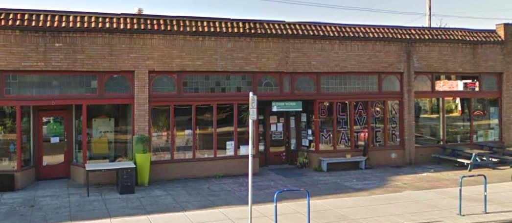
One such project in Walnut Park that received public funds was the Albina Arts Center. Located at 8 NE Killingsworth Street, the Arts Center received money from the Albina War on Poverty Fund. The center operated as a community hub, hosting concerts and plays at public parks around Northeast Portland. However, the center started to struggle after a few short years and, after not receiving grant money from the Model Cities Program, closed its doors in 1973.
This commercial block remains an important historic piece of Walnut Park and represents the different cultures and waves of the neighborhood. At the corner of NE Killingsworth and N Williams, the building houses an African American-owned furniture store, feminist bookstore, record store, and a Chinese medicine pharmacy. The independent arts culture that began with the Albina Arts Center continues today with these locally- and independently-owned stores that have become a part of Portland’s culture. (Source: Restore Oregon)
The Third Wave
Most recently, Walnut Park has experienced a third wave of demographic changes. Due to the rapid disinvestment of residential areas because of redlining and de facto segregation, the neighborhood and surrounding areas experienced a decline in property values. With property values low as a result of disinvestment, developers and middle-class white families found cheaper housing that still retained its historic character in Walnut Park and other neighborhoods of Northeast Portland. Like much of Portland, owners in the neighborhood have seen their property values exponentially increase in the last decade. These high property values continue to drive African American and lower-income families out of the neighborhood.
The history of Walnut Park is indicative of changing trends in Portland’s history. Beginning in 1904 when the neighborhood was platted, working- and middle-class European immigrants purchased land and built houses on the lots. In the 1940s, following the increase in African Americans moving to Portland to work in the shipyards, Walnut Park also saw an increase in the number of African American homebuyers during the war- and post-war periods. As urban renewal projects began, the neighborhood became the site of Civil Rights protests and displacement. Today, like much of Northeast Portland, Walnut Park is undergoing a new wave of gentrification as the city of Portland sees an increase in property values and development. (Source: Restore Oregon)
“138 of the properties [in Walnut Park], or 81 percent, were built in the early twentieth century, from the 1900s through the 1920s.”
Architecture & Construction
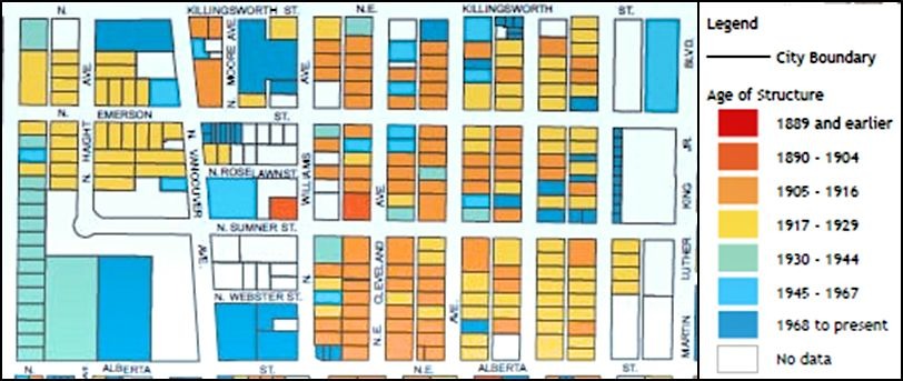
Construction Date by Decade
The buildings within the survey boundaries were built between the 1900s and the 2010s. 138 of the properties, or 81 percent, were built in the early twentieth century, from the 1900s through the 1920s. This reflects the early development and sale of lots in Walnut Park as platted in 1904. Fifty properties were built during the 1920s, the highest number for any single decade. A decrease in construction occurred in the 1930s, with only two houses built during that decade. In the 1940s, a small increase occurred with ten new houses. However, the period between the 1950s and 1990s saw only five new constructions, three of which contribute to the possible district. More recently, new construction along the Williams-Vancouver couplet and NE Garfield Avenue, by the new Vanport Square development, has led to more new duplexes and condominiums. The early 2000s up until the year of this survey have seen sixteen new properties built, comprising ten percent of structures in the project boundaries. (Source: Restore Oregon)
Building Type and Style
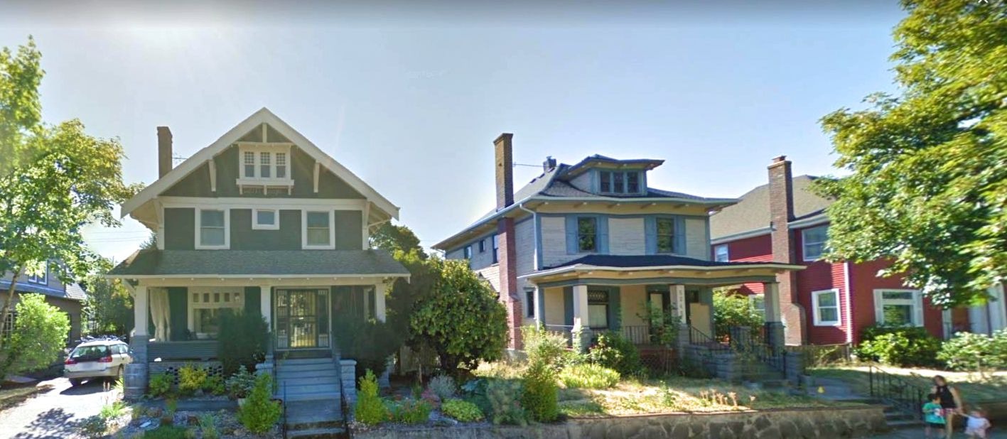
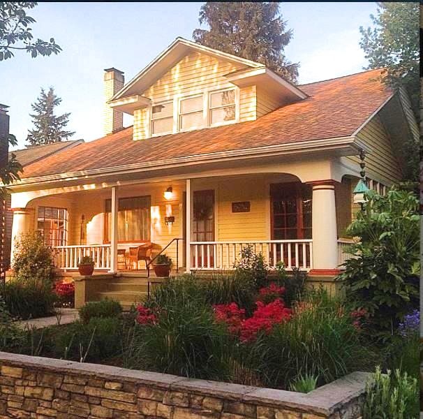
Nearly all of the properties in the survey boundaries are residential, with 167 out of 170 being domestic buildings. Of these, a majority are one and a half- or two-stories. The most common building material is wood. 77 percent of the buildings have wood as their primary material, whether this is vertical board, horizontal board, or shingle. Synthetic siding is the second most common material, but at a much smaller percentage of 13 percent.
The most common styles, 100 of the 170 properties, in the survey boundaries are craftsman and foursquare, which represent the Late 19th/20th Century American Movements in architecture. Given that many of the houses in Walnut Park were built in the 1900s-1920s, the styles represent that period of construction. Period revivals, especially Colonial Revival, are the next most prevalent style. Vernacular or undefined styles are also frequently found in the boundaries. (Source: Restore Oregon)
Historic Significance
The Walnut Park Standard Reconnaissance Level Survey contains 170 properties, all of which are buildings. The building uses are primarily residential, with one church and two commercial-use buildings. Of the 170 properties, 146, or 86 percent, are eligible/contributing to a possible historic district. Four are already listed in the National Register of Historic Places or were previously deemed eligible for listing in the National Register by State Historic Preservation Office (SHPO) staff. The National Register properties include the Emerson Apartments at 5310 N Williams Avenue (NR #99001714), the Fred Tunturi House at 5115 NE Garfield Avenue (NR #96001072), and the Jennie Bramhall House at 5125 NE Garfield Avenue (NR #99000643).
If [a] possible district is designated, these three properties should remain individually significant per their National Register status and contributing resources to the district. The Ocobock Mansion at 5128 NE Rodney Avenue is noted as eligible/significant by SHPO staff, but a National Register nomination has not been submitted. Eight are not eligible/non-contributing due to the loss of original architectural features through alterations and additions. Sixteen are not eligible/out of period due to construction dates which are out of the period of significance. (Source: Restore Oregon)